-
 As much of the nation broils under a scorching heat wave, Montana is emerging from days of heavy precipitation and unseasonably cool temperatures. Experts say that could lower the fire potential in the state this summer.
 -
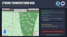 Tuesday’s near record mid-May heat will soon give way to what weather experts are describing as a wintery end-of-the-week ‘shock to the system.' A potent cold front is expected to sweep into western Montana this week, bringing gusty winds and potentially powerful thunderstorms.
 -
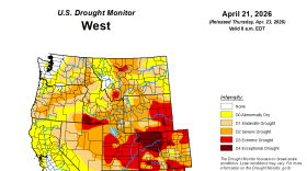 Snowpack in the West typically reaches its peak in early April but that hasn’t happened this year. Drought persists, setting up conditions for wildfires and low water supply. This warm, snowless winter points to a warming climate and trouble for Montana farmers.
 -
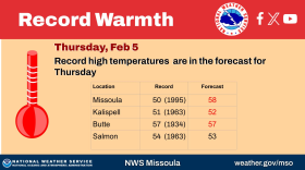
 This past winter was defined by historic warmth in the Rockies. Long-term spring forecasts look similar – warmer and drier than normal.
 -
 An elementary school near Great Falls lost a portion of its roof Sunday after severe wind battered the region.
 -
 Severe winter weather arrives in Montana this week leading to the potential for blizzards. Officials are asking people to be wary of travel plans starting Thursday. Schools in the Flathead Valley and Butte will be closed Thursday in preparation for the storm.
 -
 Lincoln County was hit hard by flooding from winter storms in 2025. Records of major floods in the area date nearly 100 years. A closer look at that history shows decades of mitigation measures, plans and preparations that officials say prevented further catastrophe in December.
 -
 Blackfeet tribal officials declared a state of emergency due to extreme winter temperatures impacting the region. The National Weather Service is forecasting a high of 6 below zero in Browning Wednesday morning, and a low of negative 13 on Wednesday night. Wind gusts may also reach up to 50 mph.
 -
 According to a recent report issued by the Department of Natural Resources and Conservation, Montana’s snowpack sits below average for this time of year.
 -
 The spring-like weather that’s gripped Montana since before Christmas shows almost no signs of going away.
© 2026 MTPR
Play Live Radio
Next Up:
0:00
0:00
Available On Air Stations


