


Montana’s independent commission charged with drawing the state into two congressional districts is expected to pick a single map for consideration this week.
There is no bipartisan support for any of the nine possible Congressional maps under consideration by the Montana Districting and Apportionment Commission.
Tuesday is the last day the commission will take testimony on the options for dividing the state into two U.S. House Districts, before making a preliminary selection days later. The commission of two Democrats, two Republicans and one nonpartisan presiding officer hope to finalize the map October 30.
Democrats put forth five possible maps and Republicans offered four. Maylinn Smith, the chair of the commission, used her tie-breaking vote to advance all nine for this weeks’ debate.
So where are they divided?
The most stark differences can be boiled down to geography, how the state’s seven Indian reservations are split and whether the districts should be “politically competitive.”
“We see that we really have to consider competing priorities,” says Christina Barsky, a University of Montana professor of public administration and policy. She says it’s not surprising that redistricting is contentious.
“The process of redistricting is the process of determining power, and parties that are in control are going to want to stay in control, parties that aren’t in control are going to want to gain political advantage.”
Those power dynamics will be in place for the next 10 years because redistricting only happens when new official census data is available.
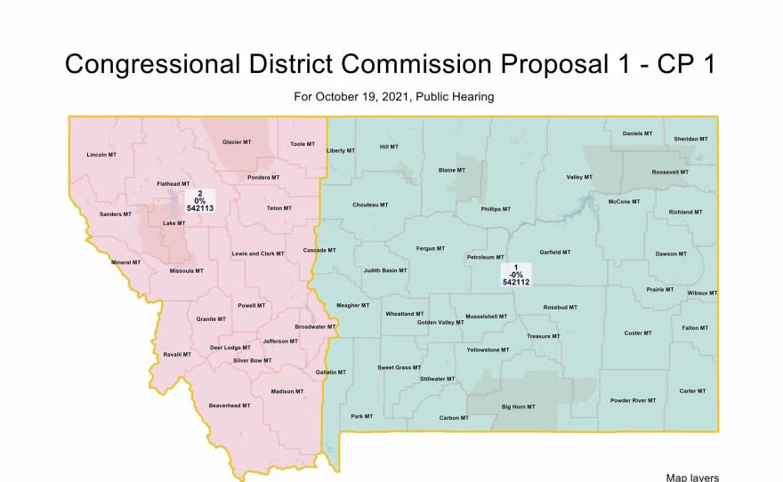
The most obvious visual difference between the nine maps comes down to geography. All four maps endorsed by Republicans imagine a wobbly line drawn down the state running from top to bottom dividing Montana into districts that are equal in population and similar in shape.
Chris Shipp, a volunteer on the Montana GOP’s districting committee, says a true east-west split is the best option because it keeps communities with common interests together.
“The congressman or congresswoman in the east could focus in on agricultural issues, those sort of things that drive our economy in the east. And people in the west could focus on issues that really drive western Montana — tourism, timber, other development. It matters who people are lumped in with.”
Shipp says these kinds of districts are the most compact, or in one piece without appendages. That’s a criteria laid out in the state’s Constitution the commission must follow.
The five maps put forth by Democrats are more varied looking, including a southwest district and south-north districts. Democrats’ maps take into account past political leanings of the places in each district.
Shipp says he believes that kind of analysis could create a safe Republican district and a safe Democratic district.
“And what that will do is that will actually increase polarization.”
Some have gone so far as to say that creating districts with political leanings in mind is gerrymandering.
Others say districts like the ones proposed by Democrats will make elections competitive instead of giving an easy win to one party, and that in turn makes the districts more middle of the road on the political scale.
Nancy Liefer, president of the Montana chapter of the League of Women Voters, says competitive districts would keep Montanans engaged in elections and make their votes more impactful.
“If you don’t look at the political implications of what you’re doing, then you can end up with a result that actually is favoring one party over the other without knowing that’s what you’re doing, and I don’t think that’s what we’re after either.”
The nonprofit advocacy group Western Native Voice is asking for the commission’s final Congressional map to have at least two tribal nations in each district, and for at least one district to be politically competitive.
Ta’jin Perez is deputy director of the organization, and says the Congressional map is particularly important to tribes because they often work with federal agencies.
“A candidate who is elected from a competitive federal district that includes these tribes will have to listen very intently, very purposefully to tribes, their issues, their needs.”
Western Native Voice is supporting two of the maps put forward by Democrats and none offered by Republicans. One puts the Blackfeet and Confederated Salish and Kootenai Tribes in a western district, but splits Kalispell, a conservative strong-hold in the eastern districts. The other splits Montana horizontally with the southern district containing the CSKT and Crow Tribe.
Although political groups are bringing conflicting ideas about how Montana should be represented in two districts, Barsky, the public policy expert, says that’s how the process is intended to go. Montana’s Constitution set up the independent districting commission to force a bipartisan solution.
“We’ve already made this decision that we don’t want it to be a process that’s controlled by a partisan Legislature.”
Montanans can make their final testimony on the nine maps on October 19th starting at 10 a.m. either in the Capitol or online.
